
|
|
Mili Island, Mili Atoll |
HISTORY
We do not know when the first people can to settle on Mili Atoll, but a date around the middle of the first millenium B.C. can safely be assumed. At the time of contact with Europeans Mile was inhabited by over 500 people. Mile as the southernmost atoll of the (eastern) Ralik Chain of Atolls saw frequent contact with people from Kiribati (former Gilbert Islands) to the south, and today a number of people of Gilbertese extraction live on Mile Atoll.
Mile first attained European fame during the beginning of the 19th century, when the mutineers of the whaleship Globe landed on Mile. In the event, the whale ship was retaken by part of the crew and sailed away, stranding the mutineers and some other crew on the atoll. Following self-destruction and attacks by the Mile people all but two Americans were killed. For over 18 months these two lived as slaves on separate parts of the atoll.
The famous blackbirder and confidence trickster Bully Hayes owned Tokowa Is. on Mile during the late 19th century and used it as a base for his pacific-wide operations. Purchasing the Marshalls from Spain in 1885, the Germans developed Jaluit as a central place. On Mile only a trading station was established; a first Christian Church came in 1870; local affairs were left with the traditional leaders. At the begin of WW I 1914 Japan took over the Marshalls.
Between the wars. After the capitulation of the German Empire in 1918, the newly formed League of Nations gave all former German possessions north of the Equator for administration to the Japanese Empire. The Japanese established a centralised district administration in Jaluit,with the internal affairs of Mile left to be handled by a local atoll authorities. There is an unsubstantiated notion that the famous aviator, Amelia Earhart who disappeared on a trans-Pacific flight in 1937, crashed in Mile Lagoon.
The Mile airbase. In the late 1930s Japan began to fortify its Marshallese possessions contrary to the Convenant of the League of Nations. These fortifications were centered on Kwajalein, Maloelap and Wotje. Any development of Mile Atoll, however, was not part in the grand strategic scheme.
Mili during World War II.
In order to create a suitable defense system
at its perimeter, the Japanese navy decided to develop some of the atolls of
the Marshall Islands into bases for seaplanes, for naval surface units
submarines, and, with the advent of long-range land-based bombers, as
airfields. Mili was only to become a small lookout, radio direction finding and
weather station. After the begin of the war and the Japanese occupation of
Kiribati, however, the strategic concepts changed. The development of Mili air
base began in in autumn 1942 when the Korean and Marshallese labour force
building the seaplane base on Majuro was transferred.
However, as the base was begun very late in the war, when Japanese resources were being stretched and when Japanese shipping was under attack by U.S. submarines, the base development is characterised by a relative absence of large concrete structures, such as command buildings, power stations or bunkers. In a very short time, between late 1942 and late 1943, the Japanese had constructed an airfield with three runways (4750', 4550' + 4400'), two hangars and a service apron. By end of 1943 there were also several hundred buildings, mainly of wooden construction, a wooden pier and several repair shops.
There was one radar set (range 50 miles) on island, giving the air wing some 10 minutes warning. During the war two squadrons of planes were temporarily stationed here many of which were destroyed on the ground. A large number of plane wrecks, mainly Zero-fighters (Mitsubishi A6M) and Betty-bombers (Mitsubishi G3M) are scattered about on the island.
The perimeter of the island, especially the ocean side, bristled with guns, which were a mixture of British and Japanese manufacture: 8 6" and 3 14cm coastal defense guns, 4 127mm dual purpose guns, 2 10cm mortars, 35 heavy and over 70 light anti-aircraft guns as well as an assortment of small guns.
Between mid-1943 and Aug. 1945, the US aircraft dropped 3350t bombs and US ships shot 450t shells onto Taroa. While the first attacks were carried-based and irregular, daily attacks were started after Majuro and Kwajalein had fallen to the US. At the same time, all supply lines to Mili were cut off, and the Japanese garrison was left to starve. Of the originally 5100 strong Japanese garrison (2600 Navy, 2500 Army,) only 2500 (50%) survived. Casualties occurred from air raids, diseases, accidents, and suicides, but mainly from starvation.
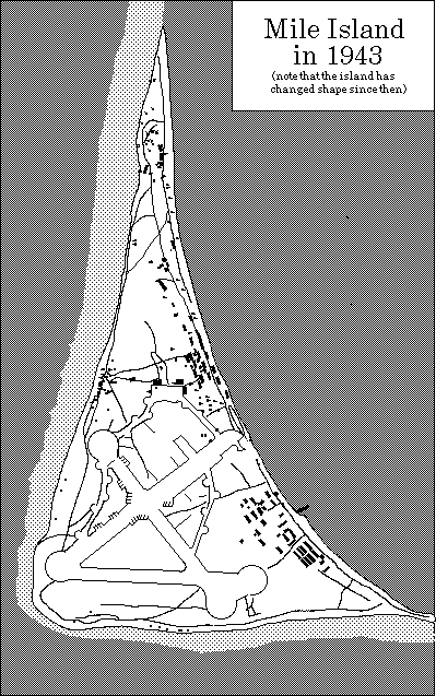
Plan of the Japanese airbase on Mili Island, Mili Atoll
TOURS AND SIGHTS
Mile Island, as you see it today, is the result of three dramatic alterations caused by people: the natural primary forest of the island had been cleared by the first Marshallese settlers and replaced, where possible, by breadfruit trees and taro pits to provide food. During the German times the breadfruit trees were largely replaced by coconut to produce copra. The final transformation came in preparation for the base development, when all trees in the center were cut down to allow for runways, taxiways, roads, barracks areas and the like. Today these areas are largely overgrown with scrub and low but very dense bush.
To some extent this impedes a visitor's progress and it can be tiring for children. Thus it is recommended that you follow a guide. A island-style lunch will be provided between noon and 1pm. Thus the day falls naturally falls into two major tour options.
We recommend that you make use of tour 1, which will give you the overview of the Island. The more intrepid visitors should stroll around the back of the village area or should explore the ocean shore at the end of the runway in the afternoon which will give you more detail. If you intend to go on the extended exploration, it is strongly advisable to bring along some water as it may get quite hot.
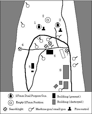
The strong point: a northern 127mm dual purpose gun position. 1-Western 127mm dual purpose gun; 2-Empty 127mm gun emplacement; 3-Eastern 127mm dual purpose gun with gun director;4-Western 100cm searchlight; 5-Power station; 6-Command bunker; 7-Eastern 100cm search light; 8-Barracks building for the gun crews.
North of the power station was the antenna field of the Mile radio station. Trained eyes may observe some of the metal spirals which once held the guy wires to the ground.
Coming to the northern tip we come to the 127mm gun battery (1-3, left figure), which is a standard feature on all Japanese defense systems throughout the Pacific. The Mile example is a textbook case, straight from the Japanese artillery manual. One can easily recognise the twin-barrelled 127 dual purpose (anti-aircraft and coastal defense) guns; there are three gun emplacements, two with guns in place (1,3), and one, spare one set out as a triangle (2). You will see several recesses in the walls of the emplacement, which were used to store ammunition to have the gun ready for firing at various angles.
Do not walk around inside the two emplacements which have the guns or step up to the guns as there is some unexploded ammunition in the emplacements which is very dangerous.
On the slight rise in the center of the triangle's base stood the gun director as well as the only radar set of the island. South of the the rise is the underground command bunker as well as an underground ammunition depot.
One can also see a network of personnel ditches around the strong point. What has gone by now are dozens of heavy and light machine gun nests which would have defended the strong point against attacks from the ground.
The guns were flanked by two powerful searchlights with 100cm mirrors; the metal bases (truncate pyramids) are easily recognisable. These guns, which were electrically driven, as well as the powerful search lights, had to be supplied by electricity, which was generated by a power station to the southwest of the gun battery. The large 6 cylinder engine, as well as cooling tanks and fuel farm are still visible.
![]()
SUGGESTED READING
There is little published on Mili's history. We recommend the following:
Chamisso, A. von, A yoyage around the world with the Romanzov exloring expedition in the years 1815-1818 in the Brig Rurick, Captain Otto von Kotzebue. Honolulu: University of Hawaii Press.
Denfeld, D.C., Japanese fortifications and other military structures in the Central Pacific. Saipan: Historic Preservation Office
Hezel, F.X., The First Taint of Civilisation. . Honolulu: University of Hawaii Press.
Michener, J., Rascals in Paradise (Mutiny on the Globe, Bully Hayes)
Peattie, M., Nan'yo: The rise and fall of the Japanese in Micronesia, 1885-1945. Honolulu: University of Hawaii Press.
![]()
![]()
Bibliographic citation for this document
Spennemann, Dirk H.R. (2000). WWII sites on Mili Atoll, Marshall Islands
Albury:
URL: http://marshall.csu.edu.au/Marshalls/html/WWII/Mili.html
![]()
CONTACT:
Dirk H.R. Spennemann,
Institute of Land, Water and Society,
Charles Sturt University, P.O.Box 789,
Albury NSW 2640, Australia.
e-mail: dspennemann@csu.edu.au
![]()
| select from the following... | ||||||
|
|
||||||
|
Digital Micronesia-An
Electronic
Library & Archive
is provided free of charge
as an advertising-free
information service
for the world community. It is being maintained by Dirk
HR Spennemann, Associate
Professor in Cultural
Heritage Management,Institute of Land, Water and Society and
School
of Environmental & Information Sciences, Charles
Sturt University,
Albury, Australia. The server
space and technical support are provided by Charles
Sturt University as part of its commitment
to regional engagement. Environmental
SciencesInformation
Sciences
|
||||||