Conservation management and mitigation of the
impact of tropical cyclones on archaeological sites

Examples from Tonga, the Marshall Islands and Australia
by Dirk H.R. Spennemann


Abstract

This paper addresses the issue of the impact of typhoons on coastal sites and the implications these present and future impacts are likely to have on policy and practice of cultural resource management. Three case studies (Tonga, Marshall Islands and North Queensland), have been drawn on to show the effects of storm surges on sites. The impact of the mitigation measures (if any) is described and placed into the context of changing global climate patterns. A number of management constraints deriving from issues of traditional ownership and conflicting values are discussed and potential solutions are advanced.

Contents

Introduction
Sites on sand dunes
Erosion by aeolian action
Erosion by wave action
Erosion by storm surge action
Cyclone "Isaac", Tongatapu (1983)
High tide, Majuro Atoll (1990)
Cyclones N. Queensland 1988/89)
Discussion
"Benefits" of storm surges
Implications of climatic change
Constraints on management options
Implications
Bibliography

Introduction

In the following paper, the impact of tropical cyclones on archaeological sites and the effectiveness of the mitigation measures which have been espoused in these cases is assessed. The paper draws on three different examples which vary in terms of geographical spread (Tonga, the Marshall Islands and North Queensland, Australia (Figure 1), types of sites (middens, cemeteries, burial monuments) and the level of cultural resource management actions and legislation in place.

Sites on sand dunes

Sites on coastal (and inland) sand dunes are prone to similar erosion processes as open camp sites. Unlike the latter, however, coastal dune systems consist largely of an unconsolidated soil matrix which makes them eminently erodible by wind and wave action. Dinner-time camps are discrete dumps of food remains, commonly shellfish, thought to represent a single meal and dumping event by individuals or a small group of people. Ethno-archaeological studies have shown that dinnertime camps were sometimes revisited and a new, discrete dumping event occurred. The archaeologically recognisable food remains varied in amount and species composition. If occupation occurred in well circumscribed areas for a prolonged period of time, or repeatedly over time, the material would accumulate and build up raised heaps of refuse intermingled with soil matrix. These middens (shell middens, kitchen middens) are especially conspicuous in coastal areas, where much of the refuse comprises shells which decay much slower than bones or even plant remains (Meehan 1982, pp. 112-115).

Erosion by aeolian action

In the "normal" course of events, if the vegetation of coastal dunes, especially fore dunes, is disturbed due to impact by (hard-hoofed) animals or people, and partial denudation has occurred, that part of the dune becomes prone to wind erosion. As these disturbances are usually perpendicular to the alignment of the dune, and in line with the main wind direction (ocean to inland), the fine sand particles are blown off towards the inland areas and a "blow-out" is created. As the erosion continues unchecked, the blow-out deepens and, with the collapse of the sidewalls, also widens. In addition, the blow-out now provides a convenient way to traverse the dune system and attracts even more animals, people and vehicles using it as a thoroughfare, thus exacerbating the problem (Zallar et al. 1979). As a result of this erosion, archaeological sites contained in the dunes, such as middens and burials, are exposed.

Continual wind erosion will remove the matrix of the site and effectively collapse and compact the vertical stratigraphy, leading to a concentration and intermingling of artefacts (of different stratigraphic layers). On a slope, a separation of artefactual material will occur, with rounded artefacts rolling down the slope and thin and lightweight artefacts being blown off by the wind. Lightweight organic matter, such as charcoal and small bones, is also dispersed, with larger bones and shells becoming exposed to photo-degradation and trampling by people and animals. Continued unchecked erosion can combine the artefactual content of midden layers, which originally had been separated by sterile horizons, thus permanently confusing site stratigraphy and chronology.

The impact of the erosion is concentrated and occurs horizontally, increasingly exposing lower desposits. Over time, the erosion will remain localised but widen out. The impact on the archeological record will also remain localised. If the parameters determining the location of sites are defined by local access points or movement corridors, then it is quite likely that modern livestock/people movement is in a similar, if not identical, location and that significant sites are predominantly affected by the erosion.

Erosion by wave action

If, however, coastal middens are exposed to water and especially wave action, the site will be eroded. The erosion impact is diffuse, affecting a large area of dunes and beach, and it is verical; that is, one section of the dune is eroded away at a time, with the erosion progressively affecting landward sites. In addition, the artefactual material will be sorted according to size and weight. This is a common phenomenon on any given beach and occurs in shells (Baan 1977, 1978a, 1978b; Lever et al. 1964) and sand/gravel sediments (Bird 1984: 143 ff).

Beaches normally undergo a cycle of aggradation and erosions, with "stable" beachlines in the long-term perspective (Bird 1984). If the sediment cycle is modified by the development of structures interfering with the currents and associated sand movements, or if the beach is subject to recurrent storm surges, then net sediment loss may occur, which has the potential to foreshorten the beach and thus, ultimately, result in the erosion of foredunes and the sites contained therein/thereon.


Figure 1. Map of the south-west Pacific, showing the location of the sites under discussion. 1-Upstart Bay, North Queensland; 2- Majuro Atoll, Marshall Islands. 3-Tongatapu, Tonga.

Erosion by storm surge action

The effects of cyclones on the coastal geomorphology of small sand cays and islands have been studied inter alia for Tonga (Woodroffe 1983), Jaluit (Blumenstock 1961), Funafuti (Maragos et al. 1973) and similar areas. Similar studies for continental shelf areas have been conducted for North Queensland (Hopley 1974a, 1974b). Studies dealing with the impact of cyclones on archaeological sites are few. Bird (1992) has described the impact of cyclones on middens in Queensland, while Hughes and Sullivan (1974) have assessed the impact of storm surges on middens in NSW. Spennemann has described the impact of cyclones on sites in Tonga (Spennemann 1987) and the Marshall Islands (Spennemann 1992a). Storm surges and tsunamis have destroyed entire archaeological assemblages on the Siassi Islands of Papua New Guinea (Lilley 1986) and elsewhere in Melanesia, and have been re-working coastal shell-middens in Australia (Hughes & Sullivan 1974) and in the Andaman Islands (Cooper 1985).

Beyond the Pacific, studies have been conducted in the US Virgin Islands and Texas following hurricane Hugo in 1989 (Gjeesing & Tyson 1990, Nelson 1991). Three of these case studies will be reviewed below:


  • Cylcone Isaac on Tongatapu in 1983;
  • A high tide at Majuro, Republic of the Marshall Islands in 1980; and
  • Cyclones in Queensland, 1988/89.

    Cyclone "Isaac", Tongatapu (1983)

    The setting

    Tongatapu ( 21o 8'S, 175o 12'W) is the southern-most major island of the Tonga Group, a raised coral limestone island covered with tephra-derived soils. The island is dominated by a large shallow lagoon in the northern part with extensive mudflats in the northeast. Beginning at the lagoonal mouth, a fringing reef extends to the north-east, which carries a number of small sand cays (Stoddart 1975; Woodroffe 1983). Two of these, Maniama and Makaha'a, are of concern here.

    Manima is a small oval sand cay, close to the mouth of the inner lagoon, extending some 150 m north-south. The island is covered with coastal broadleaf vegetation and coconut palms (Stoddart 1975; Woodroffe 1983; Spennemann 1986; Ellison 1989). The eastern and south-eastern shore of the island is dominated by expanses of a sandy beach. Conspicious are large areas of coarse sediment, which upon close inspection, proves to be the remains of an extensive pottery-bearing midden (TO-Ci-1). Present were shells (mainly Anadara sp.), undecorated pottery and volcanic (oven) stones, which do not occur naturally on Tongatapu and must have been imported from volcanic islands in the central part of the Tongan Island chain.

    Makaha'a is a small oval sand cay, 310 m long and 170 m in greatest width, on the eastern side of a reef patch isolated from the Tongatapu fringing reefs by a narrow channel about 10 m deep. It is approached through a gap in the encircling reef at its northeast point. The island has aggrading sand beaches on its west and northwest sides and flat (umu-/oven) stone spreads fronting eroded sand cliffs on its eastern side. These cliffs are 1.5-2 m high along most of the eastern shore, rising to 3 m in the southeast. Beachrock is extensively exposed, especially in the southeast, and the island is clearly migrating towards the northwest. The eastern cliff is cut in sand, exposing coconut tree roots, and is marked by fallen coconut palms and some large fallen Hernandia.


    Figure 2. An eroded pottery bearing midden in the intertidal zone of Manima Island, Tongatapu, Tonga. The broad dark band indicates the spread of stone material, pottery and large shells. The narrow dark band at the left of the image indicates the high tide mark demarcated by seaweed. Photograph: D. Spennemann 1986.

    Impact of the cyclone

    Tropical Cyclone Isaac, which hit Tonga on 3 March 1982, was undoubtedly one of the worst storms which Tonga has experienced this century. It claimed six lives and caused enormous devastation to buildings and crops. The cyclone developed about 160 km northeast of Western Samoa and travelled southwest at an average speed of 12 knots, travelling directly over the Ha'apai Group and passing some 50 km northwest of Tongatapu. In Nuku'alofa, a peak gust of 92 knots was measured. Cyclone Isaac coincided with a high spring tide of 1.2 m at Nuku'alofa. Since no tide gauge was in operation at the time of the storm, no exact record of the height of the storm surge is available. Extensive flooding of coastal areas on the northern coast and the fact that Nuku'alofa was entirely under water, testify that the water was several meters above the high-tide level. Much of the storm surge associated with Cyclone Isaac must have been buffered by the great width of reef flat along this coast (Oliver and Reardon 1982; Woodroffe 1983; Spennemann 1987).

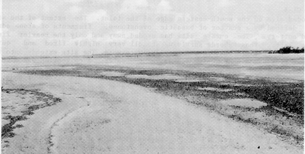
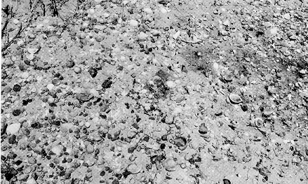
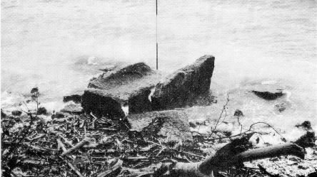
    On the islet of Manima, a pottery-bearing shell midden was completely eroded, today only recognisable as a band of shell and stones in the intertidal zone (Figure 2). A close-up view shows that only the heavy elements remain, such as oven stones, large shells and pottery (Figure 3), the fine material having been washed out.


    Figure 3. Closeup of a pottery-bearing midden site in the intertidal zone of Manima Island, Tongatapu, Tonga. The dark spots in the photographs are volcanic oven stones, the rest are shells and some potsherds. Charcoal and fine sediment has been washed out. Photograph: D. Spennemann 1986.

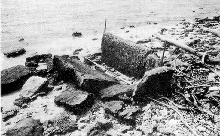
    The first archaeological survey to take place on Makaha'a was conducted in 1957 by Jack Golson. He noted a stone-lined (chiefly) burial mound on the east side of the island; it was badly eroding, with more than half of the site already washed into the sea. He also noted a burial vault, just visible in the profile. His excavation proved that the mound consisted of two construction phases, an earlier house or settlement mound and a later use as a burial mound (Golson 1957). On the occasion of the 1986 survey of Makaha'a, no trace of the stone lining could be seen and the burial vault mentioned by Golson was standing in the middle of the beach, some 2 to 3 m in front of the present sand cliff (Spennemann 1987). Only a small part (approximately 1 m) of the earth mound is still visible. Since 1957, at least 5 m of shoreline has been eroded here (Figure 4).


    Figure 4. A burial chamber of a chiefly burial mound, exposed by storm surge erosion of the coastline. Makaha'a Island, Tongatapu, Tonga. The photos show the appearance of the chamber at low (left) and high tide (right). Photographs: D. Spennemann 1986.

    Cultural resource managment actions

    In the absence of a Tongan National Heritage Management Authority at the time, the CRM action taken consisted of a survey in 1986, which was conducted as part of the author's survey for his PhD fieldwork. Erosion was also noted on other islands and recorded (for example, Spennemann 1986, 1987). In all cases, artefactual material was collected, as was the case on other sites on the main island. A report of the extent of the erosion and damage to the sites was drawn up for the Ministry of Lands, Survey and Natural Resources, which dealt with matters concerning land management (Spennemann 1986). No further action was taken. The exposure and erosion of the burial chamber at Makaha'a allowed, for the first and only time, to look at the make-up of a stone-lined burial vault. A human humerus, found wedged in under a fallen slab, thought to originate from the vault, was dated to 690 ± 180 BP (ANU-5716), thus providing the first direct date for a burial in a vault.

    Implications

    The storm surges destroyed several sites in toto and reduced others to relatively meaningless jumbles of intermingled material derived from (possibly) various phases. The late, undecorated pottery on Tongatapu is not very diagnostic (Spennemann 1989a) and with the removal of datable material (charcoal, shell) such midden sites have lost almost all their potential for analysis. This needs to be seen in the context of the horticultural potential of the sand cays compared to the fertile tephra soils of the main island. The differences in site location are likely to be a reflection of different site function, an issue that was explored by the author's excavations on Pangaimaotu, another sand cay nearby. One of the major problems thus posed is that sitestype, of which there are only a few (given the size of the sand cays), are disproportionally more prone to decay by storm surges.

    High tide Majuro Atoll (1990)

    The setting

    Majuro Atoll, situated at 7o 03'-7o 13' and 171o 02'-171o 23'E, measuring about 45 by 11 kms in dimensions, is oriented ENE-WSW and covers a total lagoon area of 295 sq km with a total land area of only 9.17 sq km. The atoll can be split into a north-western, windward side and a south-eastern, leeward one. The north-western part is characterised by large, extended reef flats with very few islands, save for the distinct Enyagin Group, which is located at the very north-western tip of the atoll and which consists of two reasonably large islands (Jelte and Rongrong). Towards the east, the islands on the northern side become more numerous and are relatively closely spaced. Located there are the three most populated islands: Djarrit, Uliga and Delap. The southern side of the atoll consisted, until 1905, of a single continuous island reaching from Rairok to Laura. The typhoons of 1905 and 1918 disrupted this continuous island, especially in its eastern part. In the south-west, the island is still intact, largely only 200 to 300 m wide, with the largest land mass, Laura (Majuro Island) at its western end (US Army Corps of Engineers 1989; Spennemann 1992b). Laura cemetery, site MI-Mj-20, is located at the lagoon side of Majuro Atoll, some 100m south of the actual tip of Majuro I. The site consists of an array of concrete grave enclosures and concrete grave monuments. According to historic evidence, the cemetery was in use in the 1910s and 1920s and contains a number of significant graves.

    Impact of the cyclone

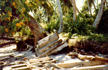
    Stable high pressure systems north-east of Eneen-Kio (Wake I.) or east of the Marshall Islands can create higher-than-normal sea levels which will cause flooding of low-lying areas if they coincide with a spring tide, or with higher wave action. Such high pressure systems are common and have affected the atolls of the Marshall Islands on numerous occasions (the 1979, 1989, 1990 and 1991 floods on Majuro Atoll for example). During Monday, 13 November 1989 and Tuesday, 14 November 1989 an exceptionally high tide occurred on Majuro Atoll, which was connected with heavy swells stemming from a high pressure cell. The high tide caused substantial erosion of parts of the lagoonal shoreline on many parts of the atoll, but especially at the northern tip of Majuro Island where some 3 m in depth disappeared. The wave action had caused several coconut palms to topple over and resulted in substantial erosion of an historic cemetery, which already had been partially eroded in the years before. The eroding shoreline exposed a number of burials and made other burial vaults to collapse (Figure 5). On the visits following the erosion, several bones were found scattered on the beach and a thorough search was made for other bones. All bones were lying in the inter-tidal zone, intermixed with coral rubble and other debris.


    Figure 5. A burial monument of the Laura Cemetery, collpased onto the beach after the 1990 high tides on Majuro Atoll, Republic of the Marshall Islands. Photograph: D. Spennemann 1990.

    Cultural resource managment actions

    The management actions espoused by the Historic Preservation Office of the Republic of the Marshall Islands, was to investigate the tip of Laura on the day after the high tide to monitor the extent of erosion. This occurred mainly as part of long-ranging interest in the geomorphological changes on Majuro Atoll; a survey of the effects of the erosion was conducted by the author on repeated occasions. In the process, the erosion of the cemetery was noted and all human bones found on the beach were picked up. This was repeated a couple of days later. The bones were identified (see below) and prepared for reburial, which took some time to be organised. Discussions with relevant local planning authorities (Environment Protection Authority, Capital Infrastructure Programme, Majuro Local Government) ensued, resulting in the conclusion that any protection against further erosion was impossible in view of both the costs involved and the potential for increased erosion at other localities due to shoreline protection works at the cemetery. It was then raised to move the cemetery to a new location, further inland, but public and informal calls through the traditional channels brought little response as to whose relatives are buried there. As it was felt that reburial without prmission of every descendant involved would not be appropriate, the initiative was called off. Thus, overall, the management was reactive, content to document the changes and the impact.

    Implications

    Given their location close to the shore, and given the relative instability of the shorelines of the islands making up an atoll, eroding cemeteries are a common occurrence in the Marshall Islands (Spennemann 1990a) and isolated human bones are often found in the inter-tidal zone (Adams et al. 1990; Spennemann 1989a, 1990b, 1990c, 1990d). More often than not, however, the human remains recovered are isolated pieces, mainly of the cranium or long bones. The differential sorting of beach sediments as discussed above, also applies to human bones of cemeteries eroding due to water and wave action. The underlying phenomenon is the differential in the velocity of the water, and hence its capability to move heavier, and hence larger, items of the same material. In addition, some of the human remains have a natural buoyancy (such as the vertebrae which are filled with spongiotic cavities trapping air) which facilitates sea-borne movement. Table 1 shows the representation of human remains found on the shore near the Laura cemetery.

    Table 1. Representation of human remains found on the beach (Majuro Atoll)
    ClassPercentageBones involved
    I 100-85% Cranium, Mandible
    II 85-50% Tibia, Femur, Humerus, Fibula
    III 50-25% Pelvis, Radius, Ulna, Axis, Clavicula
    IV 25-10% V.cervicalis, Costae, Atlas, Os sacrum
    V 10-0% Patella, V.lumbalis, V.thoracica, Metacarpus, Phalanges manus, Scapula, Ossa carpalia, Tarsus, Astragalus, Ossa tarsalia, Metatarsus, Phalanges pedis

    The two major factors involved in the observed differential preservation of skeletal elements appear to be (i) the overall weight of the bone and (ii) its ability to float. Light-weighted bones, such as the phalanges, or heavily spongiotic bones, such as vertebrae and patellae, float easily and - by wave and tidal action - can be carried out to sea, leaving the heavier bones, such as femora, tibiae, or non-floating bones, such as the crania and mandibles, behind. Given the thorough search for bones along the shoreline, both parallel and perpendicular to the water's edge, the differential representation observed is not a factor of selective recovery. However, the overall size of a bone is, on the whole, correlated with its overall weight which is the determining factor in sediment distribution along beach transects.

    It needs to be kept in mind however, that the impact of the high tide system was limited. The impact of devastating typhoons is on record for the Marshall Islands. These have eroded entire islets down to the bare reef platform, washing everything on it (houses, people, trees, soil) into the lagoon or sea (cf.Spennemann & Marschner 1994 for compilation).

    Cyclones North Queensland (1988/89)

    The setting

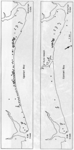
    Upstart Bay is located about 120 km south of Townsville, Queensland, between Cape Upstart and the southern end of the Burdekin River delta. The sandy beach of a shallow bay measures 13 km in length and comprises a narrow band of Holocene foredunes backed by a series of older beachridges. The beachrides are vegetated with coastal vines and an open woodland unless modified by blowouts. Archaeological surveys in the early 1980s had located a number of sites, mainly shellmiddens. This was followed by an intensive survey in 1987 which located and mapped 93 sites (Bird 1992).

    Figure 6. Distribution of archaeological sites at Upstart Bay, N.Queensland before (left) and after (right) the cyclones "Charlie" and "Aivu" (after Bird 1992).

    Impact of the cyclone

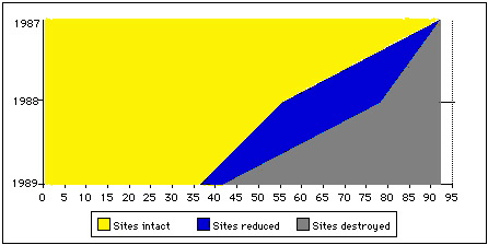
    Cyclone "Charlie" made landfall on 1 March 1988. The cyclone reached gusts of 160 km/h and created a maximum storm surge of 0.5 m at the nearest recording station (Bowen). Bird (1992) assumes the local surge height to be greater given the inshore topography of the bay. The typhoon surge breached the dune system and created an estuary at a point where the dune had been degraded by human interference. Of the 93 sites found in 1987, 14 (15%) were completely destroyed as a result of the cyclone, and a further 23 (25%) were substantially impaired. Some of the sites in the foredune were truncated, while the seaward margins of others were reworked. The sites not affected by wave action seemed to exhibit evidence of deflation by aeolian action (Bird 1992).

    Cyclone "Aivu" made landfall on 4 April 1989. The cyclone reached wind gusts of up to 200 km/h, with a maximum recorded storm surge of 1.2 m. Again, the local storm surge at Upstart Bay was much greater, approximately 3 m on the outgoing high tide. The storm surge caused substantial foredune erosion and recession of beaches; as a collateral a large number of archaeological sites was affected. Of the 78 archaeological sites that survived cyclone "Charlie", 37 were destroyed and a further five were modified or otherwise impaired (Bird 1992).

    The eroding shoreline dramatically reduced the number of sites, especially in the central section of the bay (Figure 6). If we compare the loss of sites from 1987 to 1988, then about 40% of all sites were either destroyed are modified as a result of cyclone "Charlie". Of the 78 sites surviving from the previous cyclone, another 42 sites were destroyed or (further) modified as result of cyclone "Aivu". In the final account, only 39% of all 1987 sites survived the two typhoons unscathed, 6% were reduced or modified and 55% were totally destroyed (Figure 7). In the time interval between the two cyclones, no significant redeposition of sediment had occurred and the damaged sites had been exposed to aeolian decay as well. Only in the years after cyclone "Aivu" did the dune system recover in part - resulting in the reburial of sme of the archaeological deposits (Bird 1992).


    Figure 7. Survival of coastal midden sites after the cyclones "Charlie" and "Aivu" (data after Bird 1992).

    Cultural resource management actions

    The CRM action comprised a survey of the area after the storm event and an assessment of the survival of the sites. As such then, this work is more detailed than that conducted in the previous case studies. The situation in Upstart bay is fortuitous as a cyclone event had been preceded by a systematic site survey and all sites had been mapped. This then allowed a systematic investigation of the cyclone impact after each cyclone event. Apart from the removal of a threatened burial, which had occurred well before the cyclone events, no proactive management was undertaken. Sites had been recorded and on occasions sampled, but no systematic sampling and data recovery had been undertaken (Bird 1992).

    Implications

    Even though the data retrieval has been very limited, the CRM actions taken give us an insight into the extent and speed of site decay and total site loss incurred as a result of tropical cyclones. As Bird (1992) has pointed out, the number of cyclones that hit the Queensland coast each year amounts, over time, to an exorbitant impact. If the devastation of cultural sites observed at Upstart Bay is any guide, the remaining - or surviving - archaeological record is more than impoverished.

    Discussion

    The three case studies have shown that ongoing coastal erosion poses a major threat to the conservation of cultural resources and that catastrophic events, such as cyclones, increase the impact significantly.
    • The Marshall Islands site was only affected by a high pressure system and a higher than normal sea-level and greater current activity. As a result the erosion was "gentle", exposing human remains and causing a sorting of these remains according to size classes with the lightweight bones being lost from the record.
    • The Tongan example is similar, although caused by stronger storm surges. Again, an artefact sorting occurred, with much of the midden material washed away and any stratigraphy combined into a single artefact horizon. However, parts of the sites remain, and this is in part due to the reef platform extending from the islands, and the overall shallow nature of the beach profiles.
    • In the North Queensland scenario, the beach profiles are steeper, and without the benefit of an adjacent reef platform, the storm surge is stronger and the erosive forces greater, leading to a total removal of the sites into the subtidal zone.
    Geomorphological studies have shown that much of the island formation on coral atolls is due to cataclysmic events (Maragos et al. 1973) which, on the other hand, may destroy the entire island and all the cultural deposits on it (cf. Nadikdik Atoll in Spennemann and Marschner 1994). As the examples document, the variation of the impact depends not only on the strength of the event, but also, and significantly, on the subtidal topography of the shoreline. In addition, the frequency of the cyclones affects the long-term survival of sites, as cyclones may well occur so frequently that there is little chance of a replenishment of sediment, resulting in a net sediment loss and thus a rapid decay of the sites.

    "Benefits" of storm surges

    The destructive effects of cyclonic storm surges, and the mud and sand masses carried by them, must have had their effects throughout prehistory. At times, one effect was the archaeological preservation under the mudflows of the village destroyed by them. A good example is the site of Vaito'otia-Fa'ahia on Huahine in the Society Islands (Sinoto 1983a, 1983b). Similarly, at Anuta (Kirch 1982), a cyclonic storm surge apparently capped a prehistoric settlement with a roughly 0.5 m thick layer of sand, producing a hiatus in the occupation.

    Low-intensity, continual erosion of beaches on Taroa Island, Maloelap Atoll, Marshall Islands, caused by current changes due to a World War II-period causeway, has gradually exposed a series of human remains, suggesting the presence of a cemetery nearby (Spennemann 1989b, 1990b). This was later found to be correct when an unmarked (and unrecorded) Japanese war cemetery adjacent to the shore was found after it had been vandalised by people looking for gold-filled teeth (Spennemann 1993b). In Fiji, cyclones frequently expose hitherto unknown archaeological deposits along the shoreline, so that monitoring the effects of cyclonic storm surges can be used as a "surveying" technique (Clunie, F. 1986, pers. comm.). Unfortunately, however, this is only the "poor cousin" of proper surveys (including auger surveys), as the sites thus found are usually destroyed or already severely impaired. The observations of Bird (1992) show that large-scale cyclones were only destructive and did not expose hitherto unknown sites.

    However, when assessing the actions we may wish to take, we need to consider both the likelihood and frequency, as well as strength of future hazards, and the constraints which act upon the mitigation options.

    Implications of climatic change

    One of the issues we need to consider are the implications posed by climatic change due to greenhouse gas-generated warming of the atmosphere and the related warming of the oceans. A rise in the atmospheric temperature and the sea surface temperature will generate climatic conditions favourable to more frequent and also more severe storms (Holland et al. 1988). As the sea surface temperature stands in direct correlation with the minimum sustainable pressure and hence intensity of tropical typhoons (Emanuel 1987), an increase in sea surface temperature, either during ENSO events, or as a result of Greenhouse gas-induced global warming, is likely to (Wendland 1977):

    • facilitate the occurrence of typhoons in areas hitherto not affected;
    • shift the area of typhoon generation further eastward into the central Pacific;
    • increase the frequency of storms and typhoons; and
    • increase the severity of typhoons in areas already affected by typhoons.

    Some of this can be observed today. The waters of the south-eastern equatorial Pacific Ocean undergo a quasicyclic phenomenon with a moving time interval of three to five years. During these effects, which have been termed the El Niño/Southern Oscillation (ENSO), global atmospheric disturbances develop. Based on an analysis of modern and historic data, Spenneman and Marschner (1994, 1995) have shown that the likelihood of a cyclone affecting the Marshall Islands during ENSO years is 2.6 times greater than during a non-ENSO year.

    The implications of this then, are that cyclones will become an ever-increasing threat to the cultural resource base (Rowland 1992). However, as Murphy (1990) has shown, not all events of sea-level rise need result in the devastation of coastal sites by wave erosion. In his study of site 8SL 17, he found that the site, located on the backbeach of a sand cay, was covered by a sand dune system which did not erode during the Holocene rising sea-level, but was flooded, thus preserving in situ the archaeological site underneath.

    Constraints on management options

    Above we have established that archaeological sites located on low-lying, exposed islands are highly threatened by wave-generated erosion, through both occasional storm surges and day-to-day wave action. Further, it has been shown that the climate change in train is set to increase the threat on such sites. In order to preserve the richness of our cutural heritage, the protection of such sites is of importance. Since the conservation of these coastlines is almost always rendered impossible because of the horrendous costs involved or becaue the conservation action can in fact make matters worse (cf. Bird 1992 for Upstart Bay), it would appear that a sensible solution is that most of the threatened sites should be test-excavated as soon as possible in order to recover information. If the sampling shows the site's value, the majority of the site should be open for examination. Further, more detailed excavations should follow, wherever and whenever necessary.

    However, the call to excavate is somewhat prescriptive and insensitive in view of issues such as these:

    • traditional ownership of cultural resources;
    • significance of the site to the traditional owners;
    • advances in archaeological field and laboratory methodology.

    Traditional ownership of cultural resources:

    Recent advances in CRM in Australia (Frankel 1984) as well as the USA have taken the view that the indigenous population of the country needs to be consulted when it comes to site management options. Ethically speaking, ex-colonial powers hold little moral ownership and control over the heritage created by the people they conquered. Whilst the legal parameters governing control and management of cultural heritage may permit a number of actions, one should remember that these parameters were drawn up and defined by the powers-that-be and only very rarely by those whose heritage is thus governed.

    Significance of the site to the traditional owners:

    The requirement to consult with the traditional owners of the area following appropriate procedures is paramamount if long-term management is to be successful (Spennemann & Look 1994). It needs to be considered that some of the management options, even though well-intended, may be deeemed culturally inappropriate at best, and outright offensive at worst.

    Advances in archaeological field and laboratory methodology:

    In past years, archaeological method and theory has advanced on a wide front and there is no reason to assume this will not continue. A vast array of tools has become available, ranging from optical dating to DNA analysis. Thus, it is prudent to leave sites in the ground, as they provide future generations of archaeologists with information hitherto inaccessible.

    Implications

    The above discussion has shown that cyclonic storm surges impact on shell middens and other coastal sites. From an archaeological viewpoint, abnormally strong wave action on the shoreline offers advantages and disadvantages. While wave action may expose hitherto unknown archaeological sites however, the negative impact of sites being washed away is greater. Thus, at first hand, excavation has some advantages in as much as some of the information contained in the sites can be collected and save. Yet, the excavation itself may not be an acceptable management option to the indigenous community. Site loss cannot be avoided - its impact on the level of heritage knowldge can only be minimised.

    As the Queensland case study has shown, systematic survey of the coastal shell middens and other sites allows one to accurately assess the impact of cyclones on the middens. If the survey is accompanied with a representative sampling and/or augering program (following consultation with, and consent by, the traditional owners) some of the data can be retrieved before the sites are devastated by the cyclones. The systematic resurvey of the area after the cyclone allows one to assess the extent of the erosion and site loss.

    CRM should ensure that all sites are regularly monitored to ensure documentation of all sites and their changing fate over time. This allows one to project the observed site loss back into the past and so understand the changes the archaeological record may have undergone.

    It is clear that appropriate level of management is a costly affair. Every time a cyclone strikes, the area affected by the storm surge and/or the winds, needs to be resurveyed. Ideally, the entire coastline affected by the cyclone would be resurveyed at regular intervals to monitor the gradual site erosion or site burial.

    The case studies have shown that cyclones pose a major threat to the cultural heritage and that there is no easy solution.

    Bibliography

    Micronesian Endowment for Historical Preservation, March 10, 1990, Report on file R.M.I. Historic Preservation Office, Majuro.

    Baan, G. van der (1977)
    "Een onderzoek naar het anspoolen von shelpen I", Het Zeepard 37: 94-96.

    Baan, G., van der (1978a)
    "Een onderzoek naar het anspoolen von shelpen II", Het Zeepard 38: 5-9.

    Baan, G., van der (1978b)
    "Een onderzoek naar het anspoolen von shelpen III", Het Zeepard 38: 34-39.

    Bird, E. C. F. (1984)
    Coasts: An introduction to coastal geomorphology, 3rd edition, Australian National University Press, Canberra.

    Bird, M. K. (1992)
    "The impact of tropical cyclones on the archaeological record: an Australian example", Archaeology in Oceania, 27: 75-86.

    Birdwell, K. R. & Daniels, R. C. (1991)
    A Global geographic information system data base of storm occurrences and other climatic phenomena affecting coastal zones, ORNL/CDIAC-40 Carbon Dioxide Information Analysis Center, Oak Ridge National Laboratory, Oak Ridge, TN.

    Blumenstock, D. I. (ed.) (1961)
    "A report on Typhoon effects upon Jaluit Atoll", Atoll Resarch Bulletin 75, Pacific Science Board, Washington DC.

    Cooper, Z. (1985)
    "Archaeological explorations in the Andaman Islands", Bulletin of the Indo-Pacific Prehistory Association, 6: 27-39.

    Dupon, J. F. (1984)
    "Where the exception confirms the rule: The cyclones of 1982-1983 in French Polynesia", Disasters, 8(1): 34-47.

    Emanuel, K. A. (1987)
    "The dependence of hurricane intensity on climate", Nature, 326: 483-485.

    Frankel, D. (1984)
    "Who owns the past?" Australian Society, 3 (9): 14-15.

    Gjeesing, F. C. & Tyson, G. F. (1990)
    Report on hurricane Hugo's impact on historical resources in the US Virgin Islands, St. Thomas Historical Trust and St. Croix Landmarks Society, US Virgin Islands.

    Holland, G. J., McBride, J. L. & Nicholls, N. (1988)
    "Australian region cyclones and the greenhouse effect", in Greenhouse. Planning for a climatic change, ed. G.I. Pearman, E. J. Brill, London, pp. 438-456.

    Hopley, D. (1974a)
    "The cyclone 'Althea' storm surge", Australia Geographical Studies, 12: 90-106.

    Hopley, D. (1974b)
    "Coastal changes prodiced by tropical cyclone 'Althea' in Queensland", December 1971, Australian Geographer, 12: 462-468.

    Hopley, D. & Harvey, N. (1979)
    "Regional variation in storm surge characteristics around the Australian coast: a preliminary investigation", in Natural hazards in Australia, eds R. L.Heathcote & B. G.Thom, Australian Academy of Science, Canberra.

    Hughes, P. J. & Sullivan, M. E. (1974)
    "The re-deposition of midden material by storm waves", Journal and Proceedings of the Royal Society of New South Wales, 107: 6-10.

    Kirch P.V. (1982)
    "A revision of the Anuta sequence", Journal of the Polynesian Society, 91: 245-254.

    Lever, J., Van Den Bosh, M., Cook, H., Van Dijk, T., Thiadens, A. J. K. & Thijssen, R. (1964)
    "Quantitative beach research II: An experiment with artificial valves of Donax vittatus", Netherlands Journal of Sea Geology, 2(3): 458-492.

    Lilley, I. (1986)
    Prehistoric Exchange in the Vitiaz Strait, New Guinea, PhD thesis, Australian National University, Canberra, unpub.

    Maragos, J., Baines, J. B. K. & Beveridge, P. (1973)
    "Tropical cyclone creates new land formation on Funafuti Atoll", Science, 181: 161-164.

    Meehan, B. (1982)
    From shellbed to shellmidden, Australian Institute of Aboriginal Studies, Canberra.

    Murphy, L. (1990)
    "8SL 17: Natural Site Formation processes of a multiple-component underwater site in Florida", Southwest Cultural Resources Center Professional Papers, No. 39. Santa Fe, New Mexico.

    Nelson, C. L. (1991)
    Protecting the Past from Natural Disasters, The Preservation Press, Washington, DC.

    Oliver, J. & Reardon, G. F. (1982)
    "Tropical Cyclone Isaac. Cyclonic impact in the context of the society and economy of the Kingdom of Tonga", Disaster Investigation Report No. 5, Townsville: Centre for Disaster Studies, James Cook University of North Queensland.

    Quinn, W. H. & Neal, V. T. (1992)
    "The historical record of El Niño events", in Climate since A.D.1500, eds R. S. Bradley & P. D. Jones, Routledge, London, pp. 623-648.

    Revell, C. G. & Goulter, S. W. (1986)
    "Lagged relations between the Southern Oscillation and numbers of tropical cyclones in the South Pacific Region", Monthly Weather Review, 114: 2669-2670.

    Riley, T. J. (1987)
    "Archaeological survey and testing, Majuro Atoll, Marshall Islands", in Marshall Islands Archaeology. Pacific Anthropological Records No. 38, ed. T. Dye, Department of Anthropology, Bernice P. Bishop Museum, Honolulu.

    Rowland, M. J. (1992)
    "Climate change, sea-level rise and the archaelogical record", Australian Archaeology, 34: 29-33.

    Sinoto, Y. H. (1983a)
    "Huahine: heritage of the great navigators", Museum, 137: 70-73.

    Sinoto, Y. H. (1983b)
    "The Huahine excavation: discovery of an ancient Polynesian canoe", Archaeology, 36:10-15.

    Snelson, J. M., Sullivan, S. & Preece, N. (1986)
    "Nundera Point: An Experiment at Stabilising a Fore Dune Shell Midden", Australian Ranger Bulletin, 4(1): 14-15.

    Spennemann, D. H. R. (1986)
    "The impact of cyclonic surge on archaeological sites: a case study from some low-lying islands off Tongatapu, Kingdom of Tonga", Report prepared for the Ministry of Lands, Surveys and Natural Resources, and for the Tonga Traditions Committe, Nuku'alofa, Kingdom of Tonga, Manuscript on file, Ministry of Lands, Surveys and Natural Resources, Nuku'alofa, Kingdom of Tonga.

    Spennemann, D. H. R. (1987)
    "The impact of cyclonic surge on archaeological sites in Tonga", Bulletin of the Indo-Pacific Prehistory Association, 7: 75-87.

    Spennemann, D. H. R. (1989a)
    `ata `a Tonga mo `ata `o Tonga: Early and Later Prehistory of the Tongan Islands, PhD thesis, Department of Prehistory, Research School of Pacific Studies, The Australian National University, Canberra (University Microfilms International).

    Spennemann, D. H. R. (1989b)
    "Report on a human femur from the south-western coast of Tõrwa Island, Maloelap Atoll, Republic of the Marshall Islands", Osteological Report DRS 52 (1989), Manuscript on file, Alele Museum, Majuro, Republic of the Marshall Islands, 4 pp.

    Spennemann, D. H. R. (1990a)
    "Eroding cemetries in the D-U-D area. Report on a brief survey to determine the extent of coastal erosion on the ocean side of Jarõj, Wülka and Telap Islands, Majuro Atoll, Republic of the Marshall Islands", Geomorphological Report DRS-GEO 5 (1990), Report prepared for the Historic Preservation Office, Majuro, Republic of the Marshall Islands.

    Spennemann, D. H. R. (1990b)
    "Report on a human ulna from the south-eastern coast of Tõrwa Island, Maloelap Atoll, Republic of the Marshall Islands", Report presented to the Historic Preservation Office, Majuro, Republic of the Marshall Islands (1990), Report OTIA-TAG-MAR-42-7/90, 4 pp.

    Spennemann, D. H. R. (1990c)
    "Osteological analysis of human remains from site MI-Mj-242 found at Laura Beach, Majuro Island (Laura), Majuro Atoll, Republic of the Marshall Islands", Osteological Report DRS 54 (1990), Report presented to the Historic Preservation Office, Majuro, Republic of the Marshall Islands.

    Spennemann, D. H. R. (1990d)
    "Report on part of a human cranium from Bwuron Island, Majuro Atoll, Republic of the Marshall Islands", Osteological Report DRS 56 (1990), Report presented to the Historic Preservation Office, Majuro, Republic of the Marshall Islands, HPO Report No. 2 - 1990, Manuscript on file, Historic Preservation Office, Majuro, Republic of the Marshall Islands.

    Spennemann, D. H. R. (1991)
    "Selektion menschlicher Skelettreste in ausgewaschenen Grabstätten: eine Fallstudie von den Marshall-Inseln", Archäologische Informationen, 14(1): 32-40.

    Spennemann, D. H. R. (1992a)
    "Differential representation of human skeletal remains in eroded and redeposited coastal deposits: A case study from the Marshall Islands", International Journal of Anthropology, 7(1): 1-8.

    Spennemann, D. H. R. (1992b)
    Cultural Resource Management Plan for Majuro Atoll, Republic of the Marshall Islands,, US Department of Interior, Office of Territorial and International Affairs, Washington, 2 vols.

    Spennemann, D. H. R. (1993a)
    "Multicultural Resources Management - a Pacific Perspective", Historic Preservation Forum, 7(1): 20-26.

    Spennemann, D. H. R. (1993b)
    "Observations of Vandalism at a Japanese Cemetery on Taroa Island, Maloelap Atoll", HPO-Report 1993/1, Majuro Atoll, Historic Preservation Office, Republic of the Marshall Islands.

    Spennemann, D. H. R. (1993c)
    "Toorlok Bok (Predictions of environmental, economical, social and cultural impacts of a potential rise in relative sea-level on the atolls of the Marshall Islands, Micronesia", in Climate Change: Implications for Natural Resource Conservation, ed. S. Burgin, Occasional Papers in Biological Sciences 1, University of Western Sydney, Hawkesbury, pp.185-251.

    Spennemann, D. H. R. (1994)
    Physical Conservation Techniques, Modular external study package for undergraduate course PKM 368, Open Learning Institute, Charles Sturt University, Wagga Wagga.

    Spennemann, D .H. R., Bigler, C. & Anjain, A. (1992)
    "Cultural Resource Management in the Republic of the Marshall Islands 90/91", ISLA - Journal of Micronesian Studies, 1(2): 437-444.

    Spennemann, D. H. R., Byrne, G. & Belz, L. H. (1990)
    "An outline of the potential impacts of greenhouse gas generated climatic change and projected sea-level rise on Tongatapu, Kingdom of Tonga. With special emphasis on the Nuku'alofa township area", in Implications of expected climate changes in the South Pacific region: an overview. United Nations Environmental Programme Regional Seas Reports & Studies Series, eds G. Pernetta & P. J. Hughes, 128: 161-192.

    Spennemann, D. H. R. & Look, D. W. (1994)
    "Writing Conservation Management Plans. Concepts and Considerations for Conservation Management Plans", in Conservation Management of Historic Metal in Tropical Environments. Background Notes, eds D. W. Look & D. H. R. Spennemann, No. 11. Johnstone Centre, Charles Sturt University, Albury, Australia and US Department of the Interior, National Park Service, Western Regional Office, San Francisco, CA.

    Spennemann, D. H. R. & Marschner, I. G. (1994)
    "Stormy Years. On the association between the El Niño/Southern oscillation phenomenon and the ocurence of typhoons in the Marshall Islands", Report to the Federal Emergency Management Agency, Region IX, San Francisco, Johnstone Centre Report No. 9, The Johnstone Centre, Charles Sturt University, Albury.

    Spennemann, D. H. R. & Marschner, I. G. (1995)
    "Association between ENSO and typhoons in the Marshall Islands", Disasters, 19(3): 194-197.

    Stoddart, D. R. (1975)
    "Sand cays of Tongatapu", Atoll Research Bulletin 181, Smithsonian Institution, Washington DC.

    Thorne, R. M. (1988)
    "Guidelines for the organisation of archaeological site stabilisation projects: a modeled approach", Environmental Impact Program Technical Report EL-88-8, US Army Corps of Engineers, Department of the Army, Washington, DC.

    US Army Corps of Engineers, Pacific Ocean Division (1989)
    Majuro Atoll Coastal Resource Atlas, US Army Corps of Engineers, Honolulu HI.

    Wendland, W. M. (1977)
    "Tropical storm frequencies related to sea surface temperatures", Journal of Applied Meterology, 16: 477-481.

    Woodroffe, C. D. (1983)
    "The impact of cyclone Isaac on the coast of Tonga", Pacific Science, 37: 181-210.

    Zallar, S. A., Siow, K. & Coutts, P. J. F. (1979)
    Stabilisation of coastal archaeological sites in Victoria - A pilot study, Ministry for Conservation Victoria, Melbourne.


    This document was originally published as part of " Management of Disaster Mitigation Programs for Historic Sites" edited by Dirk H. R. Spennemann and David W. Look. ( http://life.csu.edu.au/disaster/conf95/conf95.html_.


    Bibliographic citation for this document

    Spennemann, Dirk H.R. (1998). Conservation management and mitigation of the impact of tropical cyclones on archaeological sites: examples from Tonga, the Marshall Islands and Australia
    URL: http:/marshall.csu.edu.au/Marshalls/html/heritage/cyclone.html

    CONTACT:
    Dirk H.R. Spennemann, Institute of Land, Water and Society, Charles Sturt University, P.O.Box 789, Albury NSW 2640, Australia.
    e-mail: dspennemann@csu.edu.au


    © Dirk H.R. Spennemann 1995-2001